Land and People along with Yellow River
2009-11-20 15:03 BJT Mail
Mail Share
Share Print
Print
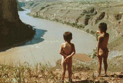
Land features of the basin have been presented in several articles in this website, and in particular, in The Yellow River Panorama, but since many readers ask me to describe more about the people and culture of the region, I will try my best to oblige these requests. Given below are several short illustrated articles depicting different topics related to daily life.
 |
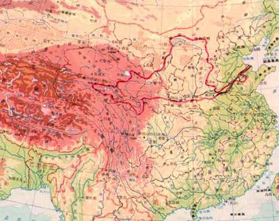
The position of the Yellow River basin is outlined in the map for East Asia on the right. It lies in approximate latitudes as the states of Virginia, Kansas, Nevada in North America, and countries like Greece and Turkey in the West.
The basin itself is divided into three parts (see map below): upper reaches, middle reaches, and lower reaches, surrounding a desert region indicated in the next map as "inland," whose rivers drain underground, and not into any tributaries of Yellow River.
 |
The basin over the upper reaches, or the Upper Basin, covers a large area, but because it is thinly populated, it is assigned a single geographical entity. The basin over the middle reaches, or the Middle Basin, includes the Loess Plateau which is an area of excessive erosion, and is the primary source of sediment in the river downstream.
This website advocates methods to control erosion in this region, and reduce sediment in Yellow River. The river in the lower reaches is lined by dikes on both sides, and since the river channel is much higher than the surrounding land, hardly any river will drain into it, and the Lower Basin is indicated by just a narrow neck within the dikes until the river exits to sea. However, people customarily consider the land north and south of the river, which receives irrigation water from the river to be the Lower Basin.
Editor: Zheng Limin | Source: CCTV.com


 Video
Video


On CCTV
Get the Channel, CCTV Live, CCTV Live in HD, CCTV-5 (Sports) Live, Latest Video, TV ScheduleCCTV-9 News Programs
Asia Today, Biz China, CCTV News, China This Week, China Today, Culture Express, Dialogue, News Hour, Sports Scene, World Insight, World Wide Watch
Newsletter
RSS
Site Map
|
Contact Us
|
About Us
|
FAQ
|
Jobs
|
Advertise
|
Privacy Policy
|
Terms of Use
 2009 China Central Television. All Rights Reserved